As for those that are not familiar with that “weird” language, I invite
them on a short trip through the remarkable history of the land. (See also
below under „Bad Bederkesa”.)
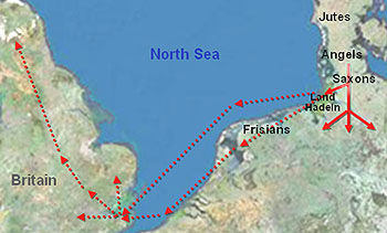 Early
Saxon migration
Early
Saxon migration
|
First proof of human settlement dates back in the Neolithic Age (e.g.
excavations in Flögeln), from about 4000 BCE. You find graves, stone tools and indications of camp
sites nearly all over the region.
The next time period about which we have some knowledge is that of the Roman
Empire or even before that. Although probably no Roman soldier had had set
foot on this soil, a good number of places of discovery show Roman, Phoenician
and Greek coins and trade goods. Presumably, Mediterranean traders sailed
past Gibraltar, circumnavigated the Iberian Peninsula, crossed the Bay of
Biscay and passed through the English Channel bound for Scandinavia’s west
coast to buy amber, the so-called “gold of the north.” Since this voyage
would have taken longer than one year, the traders are presumed to have spent
the typically stormy, icy winters at places along the coast of the North
Sea and the estuaries of the great rivers, the Elbe and Weser in this case.
Although we do not know much about local Germanic or Celtic inhabitants of
the time around the beginning of the Christian era, there is an old, never
disproved theory that Germanic divisions of the Chaucian and Thuringian tribes
had inhabited the region prior to the arrival of the
Saxons.
Saxons came from some area north of there, crossed the Elbe River and spread
southward around 200 CE. They are not believed to have come as aggressive conquerors.
(This happened during the Great Migration Period, which means that they came
with women and children.) Much rather, there are indications that they had
reached more advanced of social, agricultural and technological levels than
those of the previous inhabitants. All archaeological relics suggest that they
melted with the original inhabitants as they may have done with the
Angles prior to that.
One fine day—by now we have reached the 5th century CE—some seafarers
from the Saxon region brought home tales about a very large island in the
west, where Roman influence was declining and large tracts of fertile soil
lay ownerless. This appears to have triggered some sort of land rush. Within
the following two or three centuries many people abandoned their homes and
sailed across the wild and dangerous North Sea to the British Isles. The vacuum they left attracted some “poor and starving” Frisians. These settled in small groups along the coast, mostly with but sometimes without
Saxon permission.
It must have been a relatively peaceful time then, until he came—he, the great
Frankish king, butcher of Saxons, suppressor of freedom, augmenter and spreader
of Christianity: Charles “the Great,” better known as “Charlemagne” (742/747–814).
After long, bloody battles during the end of the 8th and beginning
of the 9th century he finally defeated the Continental Saxons and established
his power and the influence of the (his?) church by enthroning numerous beholden
and reliable vassals all over the Saxon region. Farewell, Saxon freedom!
Farewell, heathen goddesses and gods!
Yet the Saxons remained the most powerful tribe of Northern Continental
Europe, and meanwhile the Ascomannes, Danes or Vikings stood ante portas. The area on both sides of the Elbe River as well as along the Weser River became
favourite destinations of these northerners’ forays. These uninvited guests
had a great time plundering not only the new yet already wealthy monasteries
but then newly founded and thriving trading posts such as Bremen and Stade
as well. (It was also during this era that a small fortified settlement called
Hammaburg was founded—the beginning of what is now Hamburg.)
The Saxon warriors had to defend their region all by themselves. This and their
still working social class system may well have enabled them to retain more
liberty along the coasts than deeper in the southern hinterland.
Serfdom never developed anywhere in the region. Instead, the area was under the
more or less brutal sway of clerical and secular rulers, specifically under
that of the Archbishop of Bremen and the Earls of Stade.
Not so in Land Hadeln, though. Due to certain circumstances the area
came to be assigned to the domain of the Earl of Lauenburg whose main domicile lay east of Hamburg, far away from his little “gem” (German Kleinod) up there by the sea.
Rivalry between the Hanseatic
cities of Hamburg and Bremen with the Archbishop of Bremen as the third player led
to an extraordinary (maybe even unique) situation: the Hadelners were
able to run their own show in a democratic system with elected leaders
out of their own midst rather than under the tutelage of privileged aristocrats.
And this turned out to be a very handy situation for the Earl of Lauenburg:
milk and honey were flowing, which meant that a good deal of money was
flowing into his otherwise virtually empty coffers.
And here is a curious twist: for a few decades Land Hadeln was owned by the mighty
city of Hamburg, because the earl owed loan repayments to the wealthy Hanseatic
merchants. But eventually he managed to repay his debt and became the owner
of Hadeln once again.
Language
The dominant language in the region today is of course Standard
German.
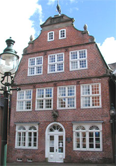
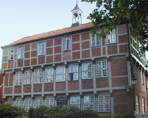 The
Latin School at Otterndorf (Low Saxon Ooterndörp) was
founded in 1614. (Courtesy RaBoe and Wikimedia
Commons)
The
Latin School at Otterndorf (Low Saxon Ooterndörp) was
founded in 1614. (Courtesy RaBoe and Wikimedia
Commons) |
In earlier times, the dominant language of the region was Low
Saxon, more or less influenced by the language of Frisian settlers (especially in
Land Wursten—See below). Already in the 13th century, the first Dutch settlers arrived in the region and brought with them their superior knowledge of dike
building. This was followed by further waves of Dutch settlers “encroaching”
upon the region and especially influencing the Low Saxon of the Sietland. (See below)
Aside from some limitations within the city of Cuxhaven, older people
living in the region are well able to understand Low Saxon. The more isolated
villages are the higher is the percentage of native Low Saxon speakers in
them.
Nearly everyone in Northern Germany below the age of 50 is able to
understand at least a little English, and particularly in the larger towns
and cities with tourist scenes this language will help you get by.
A
note for North American readers:
When Europeans say “village” they
tend
to mean what you call “town,” and
when they
say “town” they tend to mean what
to you is
a smaller or medium-size “city.” |
Travel
Guide
Getting
there
By
aircraft and train:
-
International Airport Bremen
-
shuttle bus to railway station Bremen-Hauptbahnhof
-
train to Bremerhaven and
then look for ...
-
train connection (and you might actually find one) to Cuxhaven
or:
-
International Airport Hamburg-Fuhlsbüttel
-
shuttle bus to railway station Hamburg-Hauptbahnhof
-
train to Cuxhaven via Stade
By motorcar:
If you come via Bremen (from
southern and western directions) you’ll find a comfortable Autobahn A27 (with low traffic density) leading straight to Bremerhaven and Cuxhaven.
If you enter Germany from the north or east you probably should take
a route via Hamburg, then try to find the stub of Autobahn A26 (which is still under construction at the moment), or at least follow the yellow
signs along Bundesstrasse B73 that direct you to Cuxhaven via Stade.
By
boat:
Until about two years ago we still had regular ferry service between
Harwich (England) and Cuxhaven—the last relict of the Saxon’s exodus ... The Canal Tunnel put it out of business.
I am not aware of any current regularly running public cars and passenger
ferry service between the United Kingdom and Germany. If there is none, you
would have to travel across in your own boat. In that case I strongly advise
you to seek more reliable information about navigation regulations and routes
to Cuxhaven than I am able to provide. Sailing up the Elbe estuary is a very tricky undertaking and should only be attempted
by experienced people and with excellent equipment.
Accommodation
If you like to travel off-season you shouldn’t have any trouble finding
comfortable rooms (in hotels, pensions, etc.) anywhere in the area. If you
want to stay for more than three days I’d suggest you rent an apartment. You’ll find them everywhere, even at the farthest end of the deepest countryside.
Being the centre, Cuxhaven offers the largest range of options of
course.
The lower rate range starts off very reasonably. (I believe Northern
Germany is at the lowest level in Central, Northern and Western Europe, with
the exception of Spain and Portugal.). However, you always have the option
of going for higher standards if you are willing and able to spend more money.
Things are different if you pick the main season (ca. June to September)
for your trip. In that case I’d recommend having a travel agency organise
it or just contacting me by mail or phone for specific information.
Sightseeing
Generally speaking, I
recommend visiting either in the spring, from the end of April to the end
of May, or on the last sunny autumn days from end of September until the
middle of October. There is little tourism during these times of the year,
especially in Cuxhaven. As a result of reduced pressure, locals tend to be friendlier then, as do the
prices.
A
virtual tour in and around Land Hadeln
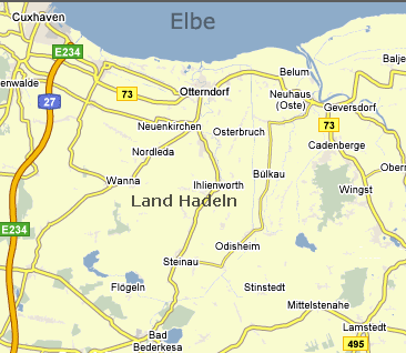
Cuxhaven
The largest town at Hadeln’s northern end is Cuxhaven (formerly Ritzebüttel),
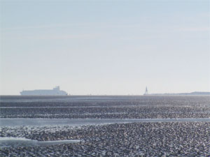
having been part of the City of Hamburg until 1937 CE. Cuxhaven isn’t a beautiful
town at all but famous as a seaside resort with the greatest tidelands at
the coast of the whole North Sea. Because of this you’ll find all kinds of
tourist accommodation.
Old Name: Koogshave (preceded
by Ritzebüttel)
Low Saxon: Cuxhoben
Missingsch: Cuxendorf
Established/first mentioned: 1872 (1394 as Ritzebüttel)
Inhabitants: 52,000
Climate: moderate, mostly cool and windy
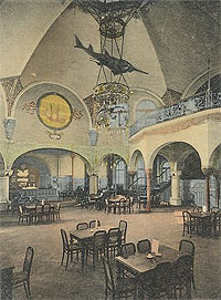
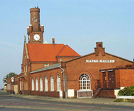 The
historic HAPAG Halls at Cuxhaven— This is one of the centers at which emigrants used
to be processed under Hamburg’s
jurisdiction.
(Courtesy RaBoe and Wikimedia
Commons)
The
historic HAPAG Halls at Cuxhaven— This is one of the centers at which emigrants used
to be processed under Hamburg’s
jurisdiction.
(Courtesy RaBoe and Wikimedia
Commons) |
Places you must visit:
Places you might visit:
-
Wrackmuseum—the ship
wreck museum
-
Fort
Kugelbake—an old navy fortress
-
Fischereihafen—the
fishing harbour
-
Neuwerk—a
small island near the shore, getting there in horse-drawn carriages at
low tide, and suddenly you’ll be on Hamburg soil, because this is a territorial
enclave
Places you should avoid:
Places to eat:
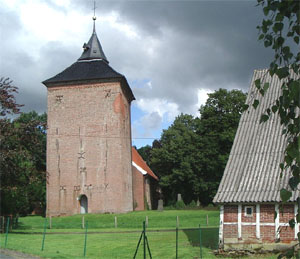
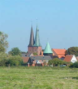
Otterndorf
Old name: Otteren Thorpe
Low Saxon: Ooterndörp
Established/first mentioned: 1261 CE
Inhabitants: 7,000
Climate: moderate, mostly cool and windy
If you go (and I recommend hiring bikes) some kilometres up along
the Elbe river, always in sight of the huge dikes protecting the land and
next to one of the most frequented waterways in the world, you’ll reach Otterndorf,
the real and historical centre of Land Hadeln. It’s a beautiful little village.
Not only tourist attractions but its historic facilities are worth looking
at. If you feel like it you can stand on usually submerged soil at low tide
even here and watch big ships going to and coming from Hamburg just some
hundred meters away. But be careful and aware of the dangerous swell at all times!
Places you must visit:
Places you might visit:
-
Kranichhaus (a
building that began in 1585, now a museum)
-
the old
church
-
Schöpfwerk and Schleuse (Europe’s
largest coastal pumping station) at the dike
Event you should avoid:
Places to eat:
-
Ratskeller in
the historic Rathaus (townhall)—excellent and expensive
-
Restaurant
Leuchtfeuer—modern and good; semi-international
-
Restaurant
Elbterrassen—panoramic view over the river
Places for drinks:
Neuhaus
on Oste, and Balje
Neuhaus:
Old name: Slickborgh, Dat
Nyge Huus
Low Saxon: Neyhuus (Neehuus)
Established/first mentioned: (1371 Slickborgh)
1404
Inhabitants: 1,266
Climate: moderate, mostly cool and windy
Balje:
Old name: Balko, Balgha, Balge
Low Saxon: Balje
Established/first mentioned: 13th century
Inhabitants: 1,108
Climate: moderate, mostly cool and windy
If you’re an experienced bicyclist and the winds are friendly you
may want continue your trip from Cuxhaven via Otterndorf to this “rotten” little village called Neuhaus/Oste. (On your return trip to Cuxhaven you might
catch a train from neighbouring Cadenberge—bike transport included in the fare.)
Although Neuhaus and Balje are not officially connected, they are de
facto so by virtue of a project built in the 1960s: the Ostesperrwerk (Oste Dam),
which is to protect the area along the Oste River against storm tides.
History has it that there used to be fights between the inhabitants
of Nordkehdingen and the authorities of the Archbishop of Bremen who had
their base in the above-mentioned Slickborgh.
Places you must visit:
-
and, as a matter of homage to the author  ... Natureum—not
a part of Neuhaus but of Balje, the “Queen of Nordkehdingen” as well as the village where a certain J. Meibohm spent the greater part of
his life—an interesting museum with much information about the region (water, land, flora,
fauna). Enjoy the view of the Oste River mouth and, on the other side, the unique Nordkehdinger Aussendeich (Outer Dike)
with the Hullen international airport (for birds only)
... Natureum—not
a part of Neuhaus but of Balje, the “Queen of Nordkehdingen” as well as the village where a certain J. Meibohm spent the greater part of
his life—an interesting museum with much information about the region (water, land, flora,
fauna). Enjoy the view of the Oste River mouth and, on the other side, the unique Nordkehdinger Aussendeich (Outer Dike)
with the Hullen international airport (for birds only)
www.natureum-niederelbe.de/ (German
only)
Places you might visit:
Places you should avoid:
Places to eat:
-
Restaurant
Zwei Linden in Balje-Hörne (cheap, modern and good)
-
Restaurant
Armer Ritter in Balje-Süderdeich (moderate prices, good meals and nice ambience)
Places for drinks:
Cadenberge
and (The) Wingst
Old name: (probably) Kadingbarg / Vingist
Low Saxon: Cumbarg (Cuddeldutt)
/ De Wingst
Established/first mentioned: 1148 / unknown, but very old
Inhabitants: 3,350 ~ 3,630
Climate: moderate
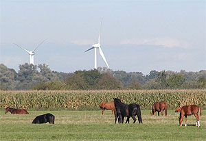
The entire region around Cadenberge is very different from the marshlands
you have ever seen. A large forest—also called the Dobrock—protects the hills, which arose during the last glacier period. Settlement—I had better say, history—of the immediate neighbourhood began from here, as “tons” of archaeological relics and some Neolithic giant’s graves prove (find out more
at Burg Bederkesa).
So it’s no surprise that the name Cadenberge means “hill
at the border.” (We can find this Caden−, also Keden−, with this meaning as a part of other place names of the areas: Altkehdingen,
Kehdingbruch, Kehdingen [formerly Kadingen], Cadewisch. Perhaps one of our interested “Lowlanners” will be the very first to find linguistic proof for relations with other Germanic
words.) And the name Wingst (vingist) denotes something like “battle field.”
If you don’t want to visit The Wingst in person now you should at
least have a look on the corresponding pictures of Google Earth. I think they’re fascinating.
Places you must visit:
-
Deutscher
Olymp, a lookout point facing one of the hills in The Wingst. You’ll have a wonderful
view of the whole region and, under good weather conditions, you
can even see far across the Elbe River
Places you might visit:
-
the old
church in Cadenberge
-
Gutshof
im Park in Cadenberge
-
the Babyzoo in
The Wingst
Places you should avoid:
Places to eat:
-
Hotel
Peter at the Bundesstraße B73/railway station Wingst—very good at medium prices
-
Butt’s
Gasthof in Wingst-Zollbaum—cheap, generous and good
-
Marc5 in
the centre of Cadenberge—modern (international?)
Places for drinks:
Sietland
(Samtgemeinde Sietland)
Low Saxon: Sietland
Established/first mentioned: between 1139 and 1370
Inhabitants: 5,683 (four villages)
Climate: moderate, wet
The area called Sietland (Low Saxon for “lowland,” usually
denoting a low-lying wet area) is, as its name suggests, the lowest-lying
part of Hadeln. It covers an area including the region that begins about
8 km south of Otterndorf, going to it’s southern border down to Bad Bederkesa and west to Wanna. Until the middle of the 20th century it was badly drained, and in wintertimes
the houses used to be regularly cut off or flooded with water. (You might
be even better informed about this than I am after you visit the Schöpfwerk at Otterndorf as I recommended.)
Because of its relative isolation, the Sietland is the area with
the largest number of native Low Saxon speakers. If you have an ear for it
you’ll probably find out that their vocabulary is influenced by Dutch and
Frisian, because many of the settlers that had enough courage to settle and
to cultivate this poor, wet soil came from the west, namely from (Eastern)
Friesland, The Netherlands and Flanders. That probably occurred, in various
waves, between the 13th and 17th century.
The landscape is dominated by water ditches and moor land, still
partly preserved as natural high moor.
Places you must visit:
I find it difficult to recommend any specific place here. I suggest
you allow yourself to take in and be impressed by the entire area. Nevertheless,
I suppose a two-hours trip by Moorbahn (moor train) should be obligatory.
Places you should avoid:
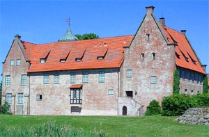
Bad
Bederkesa
Old name: Bederkesa
Low Saxon: Beers
Established/first mentioned: 1159
Inhabitants: 5,072
Climate: moderate
Bad (“Bath”)
Bederkesa, as it is called these days, has always been an important place
in the regional history. The Borough of Bederkesa at the junction of the
Archbishop of Bremen on one and the Earl of Lauenburg on the other side often
changed its owner, even up to the present.
Having been private property in the 70s of the 20th century it nearly
was a ruin before the local government bought and then restored it.
Today it is the home of both—an
interesting museum with a lot of regional history material and at the same
time the domicile of two official archaeological organisations. I believe
that this is the place to familiarise oneself with the history of the entire region.
Places you must visit:
Places you might visit:
Places you should avoid:
Places to eat:
Places for drinks:
Feddersen
Wierde and Land Wursten
If your visit of the museum in Bad Bederkesa
kindles your curiosity for some more historical stuff about Saxons and Frisians
you now should take a trip to Land Wursten.
Some people consider Hadeln and Wursten
one unit, but I don’t agree with that at all. The region of Wursten, too,
had been settled by Saxons but had been left by them during their exodus
to England. Then it became occupied by Frisian settlers who called themselves Wurtfriesen, this being the origin of today’s name. The native inhabitants still consider
themselves Frisians and remain members of the international Frisian organisation
with different names depending on their nationality (Friesenrat in Standard German).
Further “compelling” proof
for a significant difference between Land Hadeln and Land Wursten may be
the fact that my own feeling of being at home abruptly stops at the border
between those two regions ... I’m not familiar with places around there, so I’m just able to give you some
links that might help you get sufficiently informed. I hope this prevents
your getting lost in the terra incognita of the wild Frisians ...
 Resources
and acknowledgements:
Resources
and acknowledgements:
-
Erich von Lehe: Geschichte
des Landes Wursten. Mit einem Beitrag von Werner Haarnagel. Bremerhaven 1973
-
Peter Kaempfert: Französisch
im Küstenplatt
-
Willi Klenck: Heimatbuch
des ehemaligen Kreises Neuhaus an der Oste 1957
-
WIKIPEDIA- Die freie Enzyklopädie de.wikipedia.org/wiki/Hauptseite
Meinen Dank richte ich auch an meinen Nachbarn
Amandus Ahlf, der mich in vielen Gesprächen und mit Hilfe seiner umfangreichen
Bibliothek in die Geschichte des Landes Hadeln eingeführt hat sowie an Reinhard “Ron” Hahn for his support as well as for “Anglicising” this text by purging it of my most egregious linguistic transgressions, and
also for formatting this page, including making maps and selecting and processing
images.
Other
sites:
• Land
Hadeln (Wikipedia)
• Cultural
Entities: Land Hadeln
• Cuxhaven
(official site in German)
• Cuxhaven
(in English)
• Otterndorf
(official site)
• Otterndorf
(in English)
• Neuhaus
(non-official)
• Neuhaus
(Wikipedia)
• Sietland
(official)
• Sietland (follow
links to specific pages)
• Moorbahn
(official)
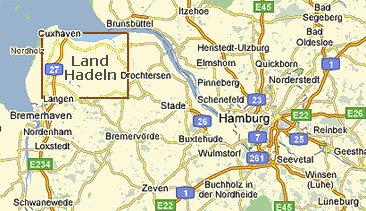
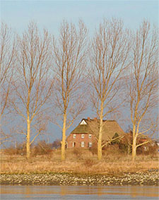
 etween the estuary of the Elbe River and the mouth of the Oste River you will find a small area with great history: Land Hadeln. Its Old Saxon name is Gau Haduloha and today it is a part of the so-called Cuxland-Region.